
What is Metes and Bounds AP Human Geography? Metes and Bounds AP Human Geography is a land surveying system that defines property boundaries using natural landmarks and man-made structures through descriptive measurements and directions. Regarding land surveying and property delineation, “Metes and Bounds AP Human Geography” is an essential concept. Unlike modern grid-based methods, Metes and Bounds employ descriptive measurements and directions, often resulting in unique and irregularly shaped plots. Read on as we explore the intricacies of Metes and Bounds AP Human Geography, tracing its historical significance and understanding its application in contemporary geography.
Real estate investors Steve Daria and Joleigh have used the Metes and Bounds system to acquire and manage properties with strategic boundaries. Their expertise in deciphering the descriptive measurements and landmarks has proven invaluable in navigating the complexities of land parcels delineated by this traditional method.
What are Metes and Bounds?
The term “metes and bounds” refers to a method of describing land by detailing its boundaries.
This system uses physical geography features—such as trees, rivers, roads, and artificial markers—as reference points to outline a tract of land.
The description generally starts at a well-defined point (the “point of beginning”).
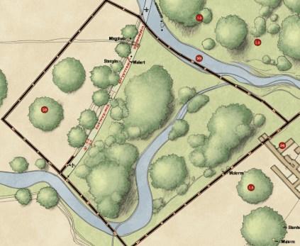
Then, it describes the parcel’s perimeter in a sequence of linear measurements (metes) and directional bearings (bounds).
Critical Components of Metes and Bounds
This section will explore the essential elements defining the metes and bounds AP Human Geography.
Point of Beginning (POB)
- Starting Reference: The Point of Beginning (POB) is the initial reference point for the property description outlined in metes and bounds. It marks where the property description begins and is crucial for accurately delineating the boundaries.
- Permanent and Identifiable Feature: The POB must be a permanent and easily identifiable feature on the property landscape. Common examples include intersections of roads, natural landmarks like rivers or trees, or artificial structures such as buildings or monuments.
Metes
- Measurement of Distance: Metes represent the measurements of distance between consecutive points along the property boundary. They are typically specified in units such as feet, meters, or yards and outline the property’s linear dimensions.
- Sequential Progression: Metes provide a sequential progression of distances, guiding the surveyor or reader along the property’s perimeter. Each mete measurement links one point to the next, accurately defining the shape and size of the land parcel.
Bounds
- Description of Directions or Angles: Bounds refer to the directions or angles that describe the orientation of the property lines relative to a fixed point, typically the POB. These directions are often specified using compass directions (e.g., north, south, east, west) or angular measurements (degrees, minutes, seconds).
- Detailed Orientation: Bounds offer detailed instructions on the property lines’ orientation, guiding the surveyor or reader in understanding the land’s boundaries accurately.
- Precision in Orientation: Including bounds ensures precision in defining the property boundaries, minimizing ambiguity and potential disputes regarding land ownership.
Example of a Metes and Bounds Description
- Begin at a large oak tree at the north corner of the property.
- Proceed 200 feet south to a stone marker.
- Turn 90 degrees west and continue 300 feet to another marker.
- Turn 45 degrees northeast and proceed 150 feet to the starting point.
👇 Tell us about your property below
No obligation. No spam. Fast response.
Historical Context and Modern Applications
Historically, metes and bounds were used in the original 13 colonies of the United States.
They are still prevalent in states like Florida, where they describe the irregularly shaped parcels of land.
Modern applications often mesh this traditional method with state-of-the-art technologies like geographic Information Systems (GIS) to ensure accuracy and clarity.
Advantages of Metes and Bounds
- Flexibility: This method is excellent for describing irregularly shaped parcels of land that do not conform to grid systems.
- Detail: Provides highly detailed and specific descriptions.
Challenges of Metes and Bounds
- Complexity: The descriptions can become unwieldy and difficult to interpret, significantly as natural landmarks change.
- Precision: The reliance on physical markers can lead to disputes if those markers are altered or destroyed.
Why Metes and Bounds Matter in AP Human Geography
In Advanced Placement (AP) Human Geography, understanding concepts like metes and bounds is crucial for comprehending how humans interact with and shape the landscape.
This system illustrates how historical land division practices impact current property boundaries and land use.
Application in Real Estate
Real estate professionals must understand metes and bounds to describe and transact properties accurately.
Misunderstandings or inaccuracies in these descriptions can lead to legal disputes and financial losses.
Tips for Real Estate Professionals
- Verify Landmarks: Always confirm the existence and location of physical markers mentioned in metes and bounds descriptions.
- Use Technology: Leverage GIS and other mapping tools to cross-check descriptions and ensure accuracy.
- Consult Experts: When in doubt, consult a land surveyor to verify the details of a metes and bounds description.

Strategies for Accurate Descriptions
- Detail-Oriented: Ensure every boundary is described with exact measurements and directions.
- Permanent Markers: Use permanent and identifiable markers for the point of beginning and other reference points.
- Regular Updates: Update descriptions periodically to account for changes in the landscape or physical markers.
FAQs about Metes and Bounds AP Human Geography
This section addresses common questions and clarifications about the metes and bounds AP Human Geography.
What is the difference between metes and bounds and other land description systems?
Metes and bounds describe land using physical landmarks and measurements, while other systems, like the Public Land Survey System (PLSS), use a more standardized grid-based approach.
Are metes and bounds still relevant today?
Yes, especially in regions with irregularly shaped parcels of land like Florida.
Modern technology enhances the accuracy and usability of this traditional system.
How can technology improve metes and bounds descriptions?
Technologies like GIS, GPS, and digital mapping tools can provide precise measurements and visual representations, making the descriptions more straightforward to understand and verify.
Can metes and bounds descriptions lead to legal disputes?
Yes, particularly if physical markers change or the descriptions are not updated regularly.
It’s crucial to ensure accuracy and consult land surveyors when necessary.
What should I do if I find a metes and bounds description discrepancy?
Consult with a professional land surveyor to resolve any discrepancies.
Accurate and updated surveys are essential for avoiding legal issues.
Conclusion
Metes and bounds AP human geography remains a fundamental way of describing the land, offering a blend of historical significance and modern applicability. Understanding this system is vital for real estate professionals, land surveyors, and property owners, particularly in regions like Florida, where irregular parcels are ordinary. By leveraging traditional knowledge and advanced technology, we can ensure accurate and reliable property descriptions that stand the test of time.
**NOTICE: Please note that the content presented in this post is intended solely for informational and educational purposes. It should not be construed as legal or financial advice or relied upon as a replacement for consultation with a qualified attorney or CPA. For specific guidance on legal or financial matters, readers are encouraged to seek professional assistance from an attorney, CPA, or other appropriate professional regarding the subject matter.