
What is Cartography? Cartography is the intricate blend of science and artistry dedicated to crafting, exploring, and harnessing maps as tools to depict landscapes and communicate spatial data effectively. Have you ever found yourself mesmerized by a beautifully crafted map, wondering about the science and art behind its creation? This fascination leads us to the core question: “What is Cartography?” Read on as we explore the essence of cartography and the practices, techniques, and technologies involved in mapmaking. Whether you are a geography enthusiast, a traveler, or someone curious about maps, understanding “What is Cartography” will give you a deeper appreciation for this fascinating field.
Cartography has applications beyond geography enthusiasts; it is crucial even in real estate investments. Real estate investors like Steve Daria and Joleigh leverage advanced mapping techniques to analyze market trends and make informed decisions about property investments. By understanding cartography, they can accurately assess locations, visualize potential developments, and strategically plan their investments.
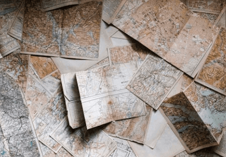
What is Cartography? The Evolution
Cartography has a rich and varied history.
Ancient maps were often rudimentary, depicting local areas and significant landmarks.
With time, technological advancements and a deeper understanding of the world led to more accurate and detailed maps.
Ancient Maps
Ancient maps were intricate works of symbolism, reflecting local geography through a lens of mythology and cultural significance.
They were more than navigational tools, often imbued with religious or political meaning, showcasing territories and landmarks important to early civilizations.
Medieval Maps
Medieval maps marked a transition, incorporating exploration elements amidst their inaccuracies.
These maps were influenced by religious beliefs and lacked scientific precision.
Yet, they offered fascinating insights into medieval perceptions of the world, featuring exotic creatures and fantastical locations alongside recognizable landmarks.
Modern Cartography
Modern cartography represents a leap forward, leveraging GPS technology and satellite imagery to produce highly accurate maps.
These maps are essential for navigation, urban planning, disaster response, and environmental monitoring, providing a detailed and reliable representation of our world’s geography.
The Role of Technology
The advent of digital technology has revolutionized cartography.
Today, Geographic Information Systems (GIS) and satellite imagery allow for incredibly detailed and accurate maps.
This technology aids in urban planning, disaster management, and environmental conservation.
- GPS: Provides real-time data and exact positioning.
- Satellite Imagery: Offers a bird’s-eye view, useful for large-scale mapping projects.
- GIS: Integrates various data layers to create comprehensive maps.
👇 Tell us about your property below
No obligation. No spam. Fast response.
Types of Maps and Their Uses
To further understand “What is cartography?” learn the types of maps and their uses:
Topographic Maps
Topographic maps are detailed representations of the Earth’s surface, highlighting features like mountains, valleys, and plains.
These maps are essential for hikers, engineers, and land developers.
- Elevation: Represented through contour lines.
- Natural Features: Rivers, forests, and other natural landmarks.
- Man-made Structures: Roads, buildings, and other infrastructures.
Thematic Maps
Thematic maps are more on specific themes or topics.
These can range from population density to climate zones, offering valuable insights into particular aspects of geography.
- Population Density: Shows the distribution of people across an area.
- Climate Zones: Helps understand weather patterns.
- Economic Activities: Highlights regions based on industries or resources.
Cadastral Maps
Cadastral maps are pivotal in land administration and real estate management, delineating precise property boundaries and ownership details.
These maps often include comprehensive information such as parcel numbers, legal descriptions, and land use classifications, facilitating accurate property and tax assessments.
- Property Boundaries: Clear demarcation of land parcels.
- Ownership Details: Information on property owners.
- Land Value: Assists in real estate assessments.
Importance of Cartography in Real Estate
What is cartography in real estate, and why is it important? Here’s why:
Land Development
Accurate maps are indispensable for land developers.
They provide insights into the terrain, helping plan construction projects and layout utilities.
- Terrain Analysis: Understanding the geographical features.
- Utility Planning: Efficient layout of water, electricity, and sewage systems.
- Environmental Impact: Assessing the impact on the natural surroundings.
Land Buyers
Land buyers use maps to make informed decisions.
Knowing a property’s location, topography, and accessibility is crucial before purchasing.
- Location: Proximity to amenities and infrastructure.
- Topography: Suitability for construction or agriculture.
- Accessibility: Ease of access via roads or public transport.
Real Estate Investors
Real estate investors rely on maps to evaluate potential investments.
By understanding the layout and value of properties, they can make strategic decisions to maximize returns.
- Property Value: Assessing the worth of a property.
- Market Trends: Identifying areas of growth.
- Risk Assessment: Evaluating potential risks such as flooding or erosion.

Strategies for Effective Cartography
To further understand “What is cartography?” Explore the strategies for effective cartography:
Accurate Data Collection
Accurate data is the foundation of any good map.
This involves using reliable sources and advanced tools for data collection.
- Surveys: Conducting ground surveys for precise measurements.
- Remote Sensing: Using drones or satellites for data gathering.
- Historical Data: Incorporating historical maps and records.
Clear and Effective Design
A practical map is accurate and easy to understand.
Clarity in design ensures that the map is user-friendly and serves its intended purpose.
- Legend and Scale: Providing clear explanations and measurements.
- Color Coding: Using colors to represent different features.
- Labels and Annotations: Clear and concise labeling of essential landmarks.
Adaptability
Maps should be adaptable to cater to different needs.
This might involve creating multiple map versions for different audiences or purposes.
- Custom Maps: Tailored to specific needs such as tourism or urban planning.
- Interactive Maps: Digital maps that users can interact with.
- Regular Updates: Keeping the maps current with the latest data.
Frequently Asked Questions
Here are the most common queries to further understand “What is cartography?”
How Accurate Are Modern Maps?
Thanks to technological advancements, modern maps are incredibly accurate.
The accuracy can change depending on the data sources and the map’s purpose.
Can Maps Be Customized?
Many cartographers offer custom mapping services tailored to specific needs like tourism, real estate, or environmental studies.
How Often Should Maps Be Updated?
Maps should be up-to-date to reflect changes in geography, infrastructure, and other relevant factors.
Critical maps typically require annual updates.
Conclusion
Understanding what is cartography and its applications can open up opportunities for map lovers, land developers, land buyers, real estate investors, and Florida residents. Accurate maps are not just tools for navigation but essential resources for making informed decisions and strategic planning. Integrating maps into your processes can enhance efficiency, gain better insights, and stay ahead in your respective fields.
**NOTICE: Please note that the content presented in this post is intended solely for informational and educational purposes. It should not be construed as legal or financial advice or relied upon as a replacement for consultation with a qualified attorney or CPA. For specific guidance on legal or financial matters, readers are encouraged to seek professional assistance from an attorney, CPA, or other appropriate professional regarding the subject matter.